This is an article about Land conversions and forest dynamics
Source: Bilingual Publishing By: Nwabueze I. Igu, Jos Updata: 09-07-2021
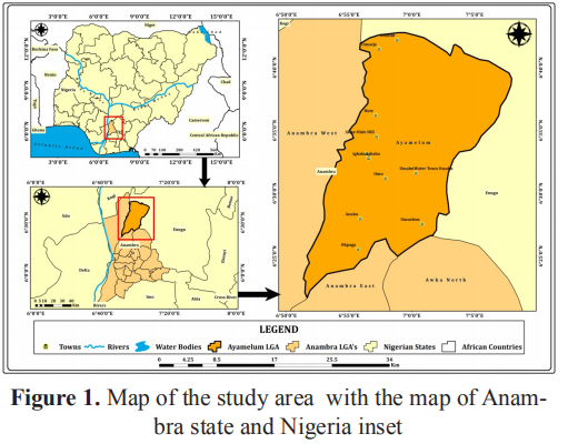
The study region (Figure 1) is located within the humid tropics where mean annual rainfall varies between 1500mm to 22500mm. Temperature condition of the area is high with mean annual temperature range of 270 C to 280 C and a peak of about 350 C between February and April [13]. It is characterized by a thick sequence of shale and sandstones formed in the Paleocene age. Soils that typify the zone are lithosol, juvenile soil, ferralitic soils and hydromorphic soils that formed under the dominant influence of the prevailing factors of geological formations of the study area [16]. It is known for its fertile soils which are seen as the underlying factor for much of the agricultural activities that dominate the zone. Crops such as yam, rice, maize and legumes are produced in large quantities in the region. Rice production have dominated the zone for a long time and with the establishment of the Anambra-Imo River basin authority, it has received much impetus and greater output.Anyamelum is a land abundant zone andother activities aside agriculture such as trading and agro-allied industries have equally grown in magnitude across the zone.
Due to the limited space, if you want to know more content, please click the link below: https://doi.org/10.30564/jgr.v2i4.1449
Hathli is the Managing Editor of the Journal of Geographical Research. If you have any questions, please feel free to contact her . Email:jgr@bilpublishing.com
Due to the limited space, if you want to know more content, please click the link below: https://doi.org/10.30564/jgr.v2i4.1449
Hathli is the Managing Editor of the Journal of Geographical Research. If you have any questions, please feel free to contact her . Email:jgr@bilpublishing.com
Tags:


